PLAYA DEL REY
  • Home
  • About
    • History
  • Visit
    • Dining & Night Life >
      • Hacienda Full Page
    • Services
    • Health & Beauty
    • Retail Shopping
    • Beaches & Parks
  • Events
    • Gillis Volleyball
    • Shack Chili Cook off
  • Surf Culture
    • Surf Stories
    • Surf Friends of PDR >
      • Robert Millner
      • Pat Rawson
      • Marcello Vercelli
  • Community
  • Shop PDR Products
    • Bottle Grips and Stickers
  • Photos
  • Contact
Picture
Picture
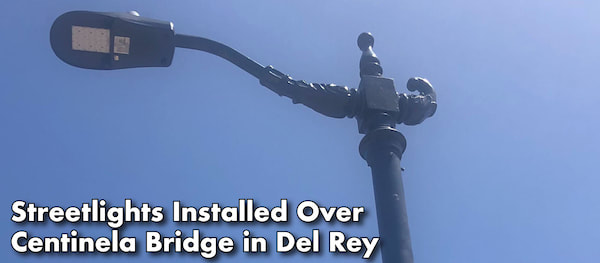
Improved lighting was added to the Centinela Bridge in Del Rey this month, completing an important community safety upgrade for the neighborhood. 
 
Thanks to a Bureau of Street Lighting crew for #GettingThingsDone and installing six light poles on both sides of the Centinela Bridge over the Ballona Creek (intersection of South Centinela Avenue and Culver Drive) in Del Rey. The new lights illuminate the sidewalk and roadway making the area safer for pedestrians, commuters, and bicyclists.

 
Picture
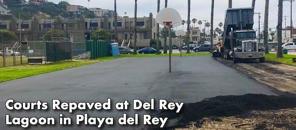
Improvements are underway at the Del Rey Lagoon Park in Playa del Rey!
 
A crew from the Department of Recreation and Parks resurfaced two full-size, blacktop basketball courts at the Del Rey Lagoon Park on Pacific Avenue, near Dockweiler Beach. The resurfacing is thanks to the generous donation of the LA Clippers Foundation and is part of a package of improvements for the community park that includes, parking lot upgrades to make the lot ADA accessible, lighting improvements to increase public safety for families using the area at night, parking stall restriping, and a series of stop sign and crosswalk installments so people can get to and from the lagoon safely.
 
Thanks to the city crew and the Clippers for helping to #GetThingsDone for our neighborhoods!


​Health Concerns About Playa Del Rey Gas Storage Facility — The Corsair
Picture

Playa del Rey: The last Beach Town

2/14/2019

4 Comments

 
by Eleanor Boba

Surf, sand, sun: the key ingredients for a California beach town. Playa Del Rey has all these in abundance. Yet the tiny community also has had perhaps more than its share of fallout from both the force of nature and the hand of man. What was once a vast complex of wetlands south of Santa Monica, and the estuary for the Los Angeles River, is now a narrow slice of coast squeezed between man-made Marina Del Rey on the north, the huge upscale housing complex known as Playa Vista to the east, and LAX so close on the south that jets soar directly over the beach.
Picture
Fredie Martel gets sand between his toes, 1942. Although the photo is labelled Playa Del Rey, it could easily be another beach community. The confines of Playa Del Rey have changed so much over the decades that names tend to get lost in the mix. Photo, Shades of L.A. Collection – Mexican American Community, #00002789.
Water, water, everywherePlaya Del Rey is a community defined by water. Ballona Creek, once a major river, cuts through the landscape as it courses from the Santa Monica Mountains down to the sea. Two centuries ago, the creek bed also channeled the Los Angeles River before that water course jumped its banks about 1825 due to earthquakes and flooding and began flowing south to San Pedro. Even without the waters of the L.A. River, Ballona Creek was a formidable stream, creating swaths of freshwater wetlands upland and saltwater wetlands as it approached the sea. A wide estuary ballooned into a lagoon surrounded by sand dunes, an ideal spot for recreational boating.

A century ago entrepreneurs dreamed dreams of pleasure pavilions, hotels, car-racing and other attractions. About the turn of the 19th century, an abortive effort was made to dredge out the wetlands and create “Port Ballona” where the railroad would meet shipping lines. Storm and tide foiled this effort and the port of Los Angeles went to San Pedro.

Dreams of a resort town had more success. The first decades of the 20th century saw a hotel and pavilion built on the lagoon with a pier on the oceanfront. Palm trees were trucked in from Santa Monica. Storm gates shielded the lagoon from ocean currents. The Pacific Electric Railway brought day trippers to the shore on its Red Cars. A funicular railroad took the adventurous straight up the bluffs. Housing started going up on the hills and along the shore to the south.

By the 1930s, things started to go sideways. The Great Depression played a part, but there were other factors. Oil was discovered in Venice, just to the north, bringing pollutants and unpleasant smells. At roughly the same time, Ballona Creek was straightened and channelized with concrete, reducing the threat of flooding, but forever changing the character of the wetlands. The lagoon shrank to a fraction of its former size. Two decades later, massive infrastructure projects to the south put the squeeze on the little beach town: the Hyperion Wastewater Treatment Plant, the Scattergood Steam Plant, and, of course, the expansion of Los Angeles International Airport. In the mid-1960s, the airport had hundreds of homes in the Surfridge neighborhood of Playa Del Rey condemned. The runways never extended quite as far as that beachfront community; one can still see ghost sidewalks and streets through a chain-link fence along Vista Del Mar, the coast road. The 1946 construction and 1955  expansion of the Hyperion plant dumped tons of sand and sediment off the coast of Playa Del Rey. While this may have compensated somewhat for beach erosion, it permanently stunted the already sleepy lagoon, cutting it off from all ocean tides.

The most significant change for Playa Del Rey, however, came when the Army Corps of Engineers began work on the project to be known as Marina Del Rey, a huge dredging project that created berths for 5,000 pleasure boats just across the Ballona Creek channel from the heart of Playa Del Rey. In effect, the Marina project, completed in 1965, cut off Playa Del Rey, geographically and ecologically, from its sister beach towns, Venice and Santa Monica, and from the northern lobe of the lagoon. The massive project destroyed 900 acres of wetland; in addition, tons of earth dredged out for the boat channels were deposited off Playa Del Rey. Once again the town became a dumping ground.

In more recent years, residents have had to fight to keep even a small portion of the wetlands that defined the community from falling to development. Beginning in 2002, the Playa Vista development threatened to destroy a good chunk of the remaining freshwater wetlands for upscale housing, businesses, and offices.  Negotiation and mitigation has allowed for the preservation and interpretation of some 600 acres of wetlands, now in the care of the California Department of Fish and Wildlife. Plans are afoot to restore the much changed wetlands to some version of their former selves. Meanwhile, in the lowlands, the little community of Playa Del Rey retains a relatively low profile among beach towns.

Water, water, everywhere
Playa Del Rey is a community defined by water. Ballona Creek, once a major river, cuts through the landscape as it courses from the Santa Monica Mountains down to the sea. Two centuries ago, the creek bed also channeled the Los Angeles River before that water course jumped its banks about 1825 due to earthquakes and flooding and began flowing south to San Pedro. Even without the waters of the L.A. River, Ballona Creek was a formidable stream, creating swaths of freshwater wetlands upland and saltwater wetlands as it approached the sea. A wide estuary ballooned into a lagoon surrounded by sand dunes, an ideal spot for recreational boating.
A century ago entrepreneurs dreamed dreams of pleasure pavilions, hotels, car-racing and other attractions. About the turn of the 19th century, an abortive effort was made to dredge out the wetlands and create “Port Ballona” where the railroad would meet shipping lines. Storm and tide foiled this effort and the port of Los Angeles went to San Pedro.
Dreams of a resort town had more success. The first decades of the 20th century saw a hotel and pavilion built on the lagoon with a pier on the oceanfront. Palm trees were trucked in from Santa Monica. Storm gates shielded the lagoon from ocean currents. The Pacific Electric Railway brought day trippers to the shore on its Red Cars. A funicular railroad took the adventurous straight up the bluffs. Housing started going up on the hills and along the shore to the south.
By the 1930s, things started to go sideways. The Great Depression played a part, but there were other factors. Oil was discovered in Venice, just to the north, bringing pollutants and unpleasant smells. At roughly the same time, Ballona Creek was straightened and channelized with concrete, reducing the threat of flooding, but forever changing the character of the wetlands. The lagoon shrank to a fraction of its former size. Two decades later, massive infrastructure projects to the south put the squeeze on the little beach town: the Hyperion Wastewater Treatment Plant, the Scattergood Steam Plant, and, of course, the expansion of Los Angeles International Airport. In the mid-1960s, the airport had hundreds of homes in the Surfridge neighborhood of Playa Del Rey condemned. The runways never extended quite as far as that beachfront community; one can still see ghost sidewalks and streets through a chain-link fence along Vista Del Mar, the coast road. The 1946 construction and 1955  expansion of the Hyperion plant dumped tons of sand and sediment off the coast of Playa Del Rey. While this may have compensated somewhat for beach erosion, it permanently stunted the already sleepy lagoon, cutting it off from all ocean tides.

The most significant change for Playa Del Rey, however, came when the Army Corps of Engineers began work on the project to be known as Marina Del Rey, a huge dredging project that created berths for 5,000 pleasure boats just across the Ballona Creek channel from the heart of Playa Del Rey. In effect, the Marina project, completed in 1965, cut off Playa Del Rey, geographically and ecologically, from its sister beach towns, Venice and Santa Monica, and from the northern lobe of the lagoon. The massive project destroyed 900 acres of wetland; in addition, tons of earth dredged out for the boat channels were deposited off Playa Del Rey. Once again the town became a dumping ground.

In more recent years, residents have had to fight to keep even a small portion of the wetlands that defined the community from falling to development. Beginning in 2002, the Playa Vista development threatened to destroy a good chunk of the remaining freshwater wetlands for upscale housing, businesses, and offices.  Negotiation and mitigation has allowed for the preservation and interpretation of some 600 acres of wetlands, now in the care of the California Department of Fish and Wildlife. Plans are afoot to restore the much changed wetlands to some version of their former selves.

Meanwhile, in the lowlands, the little community of Playa Del Rey retains a relatively low profile among beach towns.
​
Watching change unfoldPhotos from the Los Angeles Public Library’s collection show the startling transformation of Playa Del Rey over the past century.-


Picture
Picture
Picture
4 Comments

Help protect our Wetlands...

8/10/2018

2 Comments

 
Picture
Friends of Ballona Creek Calendar

Restoring Southern California's Wetlands Video
Picture
2 Comments

The Gillis is Coming...

6/25/2018

3 Comments

 
Picture
3 Comments

Shack Chili Cook-off June 23rd!

6/21/2018

1 Comment

 
Picture
1 Comment

The Gillis Volleyball Tournament #48

5/17/2018

4 Comments

 
Coming July 28th... Toes Beach

The Gillis Volleyball Tournament was started in 1971 by Steve and Dave Cressman at Gillis Beach, in Playa del Rey, California. That first year, 17 teams participated, playing on one court. At this year’s 40th tournament, there will be 170 teams with over 600 players, playing on 28 courts.
Gillis Beach was named after a one block-long street in Playa del Rey called Gillis Street that ended at the sand. Junior high and high schoolers from Westchester High and St. Bernards High learned what the Southern California beach lifestyle was all about. The beach shoreline community was wiped out though in 1974 by expansion of the LA Airport’s west runway. Although the neighborhood and homes were gone, The Gillis tournament continued there until 1980. It was that year when the city dredged the marina of sand and dumped it on Gillis Beach, destroying the 10 courts that had been built over the previous 10 years. The tournament was then forced to moved to Toes Beach, 1 mile north, for a run of 25 years. In 2005 the county forced another move on The Gillis to the southern-most point of Playa del rey called Dockweiler Beach. The history of Playa del Rey and of Gillis Beach is preserved through the tournament each year as a reunion for those that grew up here. This makes the Gillis a “locals” event like none other.
Picture
4 Comments

May 12th, 2018

5/12/2018

4 Comments

 
4 Comments

    Author

    PDR Mike, is proud to be a long time PDR resident. He's passionate about our community and has created this site to benefit both tourists, residents and local businesses. If you have any stories, photos, or upcoming PDR related events, we would love to share them. Please contact PDR Mike.

    Archives

    February 2019
    August 2018
    June 2018
    May 2018

    Categories

    All

    RSS Feed

Location

People are saying...

"Playa del Rey is the best kept secret in Los Angeles"

Contact Us

    Sign up to be the first to know about special  events, business news, advertising specials, and history of our charming beach town.

Subscribe
  • Home
  • About
    • History
  • Visit
    • Dining & Night Life >
      • Hacienda Full Page
    • Services
    • Health & Beauty
    • Retail Shopping
    • Beaches & Parks
  • Events
    • Gillis Volleyball
    • Shack Chili Cook off
  • Surf Culture
    • Surf Stories
    • Surf Friends of PDR >
      • Robert Millner
      • Pat Rawson
      • Marcello Vercelli
  • Community
  • Shop PDR Products
    • Bottle Grips and Stickers
  • Photos
  • Contact